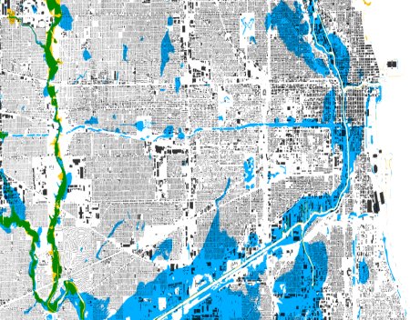
Different Types of Flood Zones
Flood zones play a major role in determining a property's flood risk, insurance requirements, and long-term ownership costs. Yet many homeowners and homebuyers don’t fully understand what these zones mean or how they affect their property.
Flood zones are geographic areas that indicate the likelihood of flooding based on historical data, rainfall patterns, topography, and nearby water sources.
Understanding the different types of flood zones can help homeowners make smarter decisions about insurance, property purchases, and risk management.
A flood zone is a classification used to describe how likely an area is to experience flooding.
These zones are identified using Flood Insurance Rate Maps (FIRMs) created by the Federal Emergency Management Agency (FEMA). Each zone indicates a different level of flood risk.
Flood zones influence:
Flood insurance requirements
Flood insurance premiums
Mortgage lender requirements
Property resale value
Even if a property is located in a lower-risk zone, flooding can still occur.
High-risk flood zones are often called Special Flood Hazard Areas (SFHAs). Properties in these zones have the highest probability of flooding.
Homes located in these zones typically require flood insurance if the buyer uses a federally backed mortgage.
Zone A is one of the most common high-risk flood zones.
Characteristics include:
1% annual chance of flooding
Base flood elevations may not be fully determined
Flood insurance usually required for financed properties
Zone AE is similar to Zone A but includes established base flood elevation (BFE) data.
This means flood maps show how high floodwaters are expected to rise during major flood events.
Elevation data helps insurance companies determine premiums more accurately.
Zone AH areas face shallow flooding, typically caused by heavy rainfall or drainage issues.
Floodwater depths in these zones usually range between one and three feet.
Zone AO zones experience sheet flow flooding, where water moves across the ground rather than overflowing from a river or lake.
Flood depth estimates are often included in flood maps for these areas.
Zone VE areas are coastal locations that face storm surge and wave action.
These zones are considered some of the highest-risk flood areas due to:
Coastal storms
Hurricanes
Wave velocity
Storm surge flooding
Homes in VE zones often have strict building requirements to withstand wave impact.
Moderate-risk flood zones are areas where flooding is possible but less likely than in high-risk zones.
Shaded Zone X areas represent moderate flood risk, often located near high-risk zones.
Flood insurance is usually optional in these areas but still recommended.
Low-risk flood zones have the lowest probability of flooding, but they are not completely risk-free.
Unshaded Zone X areas represent minimal flood risk based on historical data.
These areas typically do not require flood insurance, although homeowners may still choose to purchase coverage for extra protection.
Flood zones can affect homeowners in several important ways.
Properties in high-risk zones often require flood insurance if the homeowner has a federally backed mortgage.
This coverage is separate from standard homeowners insurance.
Flood zone classification directly affects flood insurance premiums.
Homes located in high-risk zones generally have higher insurance costs compared to properties in lower-risk areas.
Flood zones can influence property value and buyer demand.
Some buyers may hesitate to purchase homes in high-risk flood zones due to insurance costs or potential flooding concerns.
However, in waterfront or coastal areas, flood zones are common and often expected.
Homeowners and buyers can determine flood zone classifications using several resources.
The FEMA Flood Map Service Center provides detailed flood maps that allow users to search properties by address.
These maps show flood zone boundaries and risk levels.
City or county planning departments may also provide flood zone information and floodplain maps.
They can sometimes offer additional details about local flood risks.
An elevation certificate measures how high a structure sits relative to expected flood levels.
This document can help determine flood risk and may reduce insurance premiums if the home is elevated above the base flood level.
Flood zones are an important factor in understanding property risk and insurance requirements.
The main flood zone categories include:
High-Risk Zones
Zone A
Zone AE
Zone AH
Zone AO
Zone VE
Moderate-Risk Zones
Zone X (shaded)
Low-Risk Zones
Zone X (unshaded)
Knowing your property’s flood zone can help you make better decisions about insurance coverage, property investments, and long-term financial protection.
Even homes outside high-risk flood zones can experience flooding, which is why understanding flood risk is an essential part of responsible homeownership.

I have known Tim for many years and he is a man with great integrity, work ethic and one of the nicest persons I know. Over the years Tim has provided insurance counseling and advice to our company, for myself personally, as well as to our clients. Recently Tim, took time to analyze our flood insurance policy and he was able to make some excellent recommendations. Our flood insurance costs are now less and we have much better coverage. I recommend Tim to anyone without hesitation or reservation.
I have no problem giving you an A1 reference for taking care of the flood policies for me and Diane. I appreciate you working with the mortgage company: the surveyor and our previous agent. The result was a 75% reduction in our flood insurance premiums!
We contacted Mr. Holt for an estimate via email over the weekend prior to a closing on a property, hoping for a response on the following Monday to take with us with confidence in being insured at the settlement table on a Tuesday. He exceeded our expectations not once but in readily responding to the initial request and then to follow-up questions all during the weekend frenzy that occurs before closing. "Impressive and responsive customer service," for sure!
We'll help you:
Lower your current flood insurance premiums
Eliminate excessive & unnecessary coverage
Remove the FEMA from the claims handling process